Monday, August 23, 2010

Ireland 2010: The Blasket Islands

The Blasket Islands are a group of islands just west of the Dingle pennisula, the western most point of Ireland.  The Great Blasket (An Blascaod Mo'r) is the largest, at about 3 miles long and 1/2 mile wide.  The Blaskets were inhabited (two of them) for several hundred years, apparently by some extremely hardy souls-- there is not a tree or a bush to be found.  Population declined somewhat during the potato famine of 1845-1851, then rebounded to peak at about 120 with 23 families.  (It must have been terribly crowded in these small cottages!)  It began to decline after WWII until 1953 when the remaining residents abandoned the island.  (Many of the young adults were leaving to go to America, sending home money once established to enable another emigrant to leave.  Finally there were too few able bodied souls to sustain life on the island.)  Residents made their living by fishing, lobster trapping, and raising a few sheep.
Today most of the buildings on Great Blasket have fallen into ruin-- although one or two are privately owned as "get aways" (?)  A small ferry runs every hour from Dunquin (weather permitting), mostly bringing tourists to visit the island.
A visitor center has been built in Dunquin that gives the history and culture of the Blasket Islands, and their residents.  Several authors and scholars came to the islands in the early 1900s to rediscover the Irish language and folklore, which had disappeared from much of Ireland, publishing several books.
Dunquin Pier--  This is the pier in Dunquin where the ferry to Great Blasket Island embarks.  The pier is in a small inlet at the bottom of a cliff-- quite a climb out.  The tides in Ireland are large (it's far north)-- at low tide the ferry cannot come into the pier, and passengers must be transported to/from the pier and ferry by a small Zodiac boat.  The ferry passengers must be loaded and unloaded from the ferry using the Zodiac in all tides at Great Blasket, as the pier there is very primitive and small.
The boats on the pier are fishing/lobsterman boats used in this area (for a very long time).  They are constructed of wood framing with canvas stretched over it, then tarred.  In older days the boats had oars and a small sail.  Most of the modern boats have a well to receive a small outboard motor.
Blasket Islands--  Beyond the rock outcropping in the foreground is Great Blasket Island (An Blascasod Mo'r).  You can just make out some of the buildings on it (The village).  Just to the right, is a low lying island of  Beginish (Beiginis).  Behind Great Blasket (the bump) is Inishtooksert (Inis Tuaisceart).  The photo is taken from the beach area directly next to the Dunquin Pier--  low tide.
Ferry "Blasket Queen"--  Blasket ferry passengers Nate, Elaine and Isabelle headed to the Great Blasket Island on tour


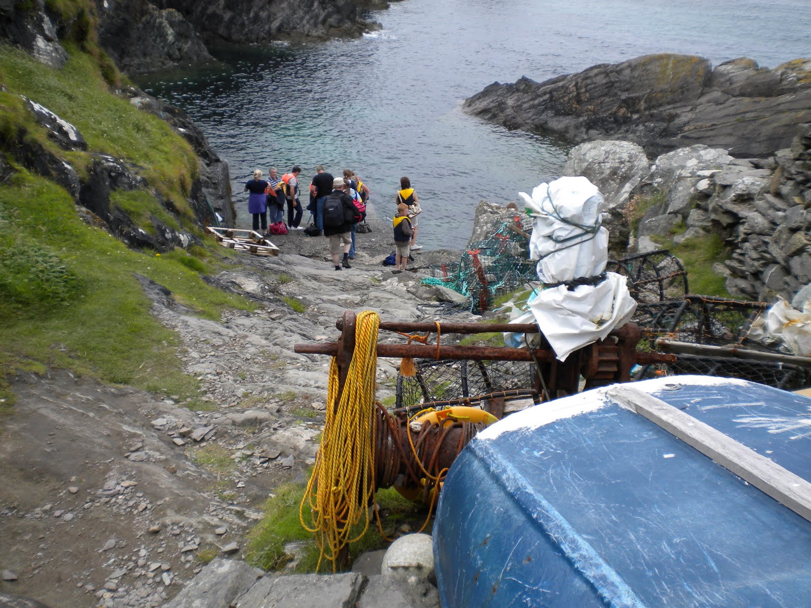
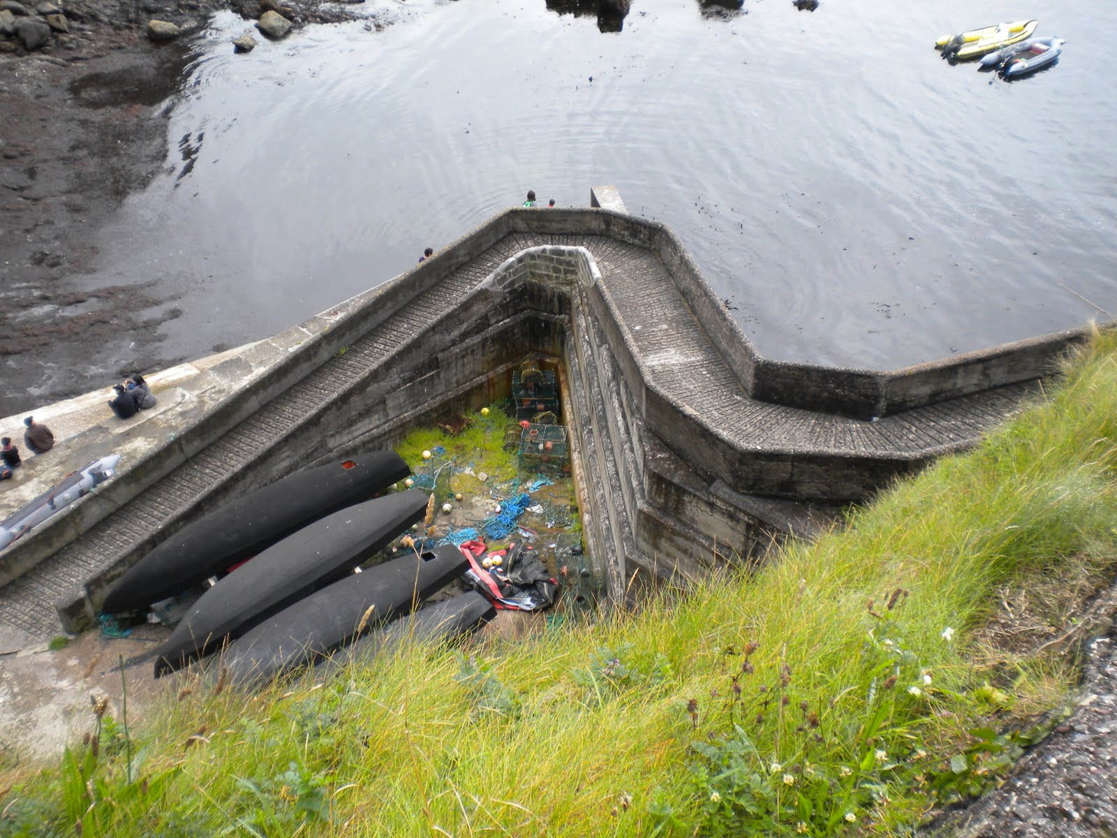
The Great Blasket Island Pier and Port--  This is what served as the "pier" on GBI.  There is a something of a concrete ramp where the people are standing, and a rocky incline up to a cable winch (in the foreground, with yellow rope on it).  To the right of the people there is a sea wall.  We are waiting for the ferry (the LAST ferry of the day!) to come pick us up.  Miss the ferry, and you are camping over night.
Blasket Island Ramp--  Looking up from the lower ramp, the upper ramp and path to the GBI pier is merely stone.  (You can see the winch and rope from the lower ramp picture here)
Sea Wall--  This sea wall added some protection to the small inlet and boat ramp on GBI.  It is about 15 feet tall. It was constructed in the 1920's--  perhaps the unprotected beach was used  for landing boats prior to pier and sea wall construction.
Blasket Ruins--  Skeletons of the houses on Blasket Island.  The one cottage that is in good shape appears to be under renovation by someone-- perhaps a weekend cottage.
Bunny--  The Great Blasket Island has rabbits and sheep (at least)
Inishvickillane (Inis Mhic Aoibhlea'in)island--, one of the smaller Blaskets has only resident.  In the 1970's the Irish government populated the island with red deer.  There are now several hundred deer (visible on the ridge) on the island today.

There are five islands in total in the Blasket chain:

  • Inishtookskert (Inis Tuaisceart)

  • Beginish (Beiginis) (Great Blasket)

  • Great Blasket Island (An Blascaod Mo'r)

  • Inishnabro (Inis naBro')

  • Inishvickillane (Inis Mhic Aoibhlea'in)

Sunday, August 22, 2010

Ireland 2010: Irish Meals

One of the best things about Ireland is the food-- not always the cuisine, but the quality and freshness of the produce available there.  Butter, eggs, and the fish and meats are all really excellent.

But better than having good produce is having good produce AND to be traveling with a trained and certified chef.  As we were touring the Dingle peninsula I noticed lobster traps along the coastal shores and on the Dunquin pier.  So it seemed fresh lobster should be readily available.  With guests arriving from out of town to visit (friends of Nate's from Edinburgh, Scotland) a major dinner was planned.  Nate and Elaine went to the market, returning with two lobsters, as well as crayfish and a whitefish.


Let the picture tell the story--  it was all wonderful!

Friday, August 20, 2010

Ireland 2010: Anascaul and Fly Fishing

As a avid fly fisherman, traveling to Europe, and in particular Ireland, without at least a day on the water would be a disappointing holiday.  I carried along an abbreviated set of fly fishing tackle with the intention of doing some fishing in mind.  The Dingle peninsula is not a major area for fresh water fly fishing but there are loughs and creeks with trout.  The local tourist information center suggested Lough Anascaul (The Irish name is Abhainn an Sca'il), so we planned an outing and picnic to the lake.
The creek and bridge in the village of Anascaul
We have been to Anascaul on previous visits to Ireland, but mostly just a quick stop on  our way.  Anascaul is a small village east of Dingle, with a beautiful creek running through it (flowing out of Lough Anascaul).  The noteriety of the village is due to its most famous resident, Tom Crean who was a member on three Antarctic expeditions, and heroic member of both Robert Scott's British Antarctic Expedition (Terra Nova) of 1910-1913 on the ship Terra Nova and Ernest Shackleton's ill-fated Imperial Trans-Antarctic Exhibition of 1914-1917 on the ship Endurance.  He was also a member of Scott's failed first expedition Discovery in 1901-1904.  He returned to Annascaul following his naval and exploration career to open a tavern called the South Pole Inn, which is still open today.

Anascaul Lough--  A small lake above the village Anascaul.  The quiet of picnics and fishing here are interrupted only by occasional bleating of sheep on the far shore.
Lough Anascaul is above the village by a few kilometers, below a small cirque.  We stayed only a few hours but had a wonderful picnic and outing.  Isabelle was able to land her first trout--  hopefully planting a seed of enjoying the outdoors and fishing for future years.
Nate trying his hand at fly casting for the brown trout in Lough Anascaul.
Tom Crean--  A monument to Antarctic explorer Tom Crean is found in Anascaul's small park.
South Pole Inn--  Tom Crean's tavern in Anascaul.  The tavern has a beautiful location, on the creek just past the bridge into town.  Of course, we stopped and had a pint of Guinness before making our way back to Dunquin at the end of the day.
South Pole Inn--  There are many photos and newspaper articles on the walls honoring the explorer Tom Crean.
There was a group of locals fishing at the lake as well, using spinning gear.  Shortly after we landed the second trout (both were very small-- see picture below)  I noted that one of the fishermen went to his car and and switched to using a fly rod (he was a good caster too!).  Perhaps the ability to target and cast to rising trout with a fly rod brought him back to his senses!
Irish Trout--  Isabelle with her first catch (assist, anyway).  Not very large but a beautifully colored Brown trout.

I did not bring wading gear with me, and decided to get some "Wellies" while in Dingle.  These worked out pretty well for the lough.  While in the shop, the sales girl, in the best Irish accent asked me, "So are ye plannin' to do some farmin' while you're on holiday here in Ireland?"
Not to be outdone, Isabelle got a pair of her own Wellies, in hot pink,  from grandma.


Ireland 2010: Dingle Harbor and Fungi

One of the celebrities of Dingle is Fungi-- the dolphin.  Some smart, enterprising dolphin wandered into Dingle Bay several years ago and decided to hang around.  Tourists were interested, and voila-- a new enterprise was born--  boat tours to see Fungi.  Of course seeing Fungi is popular with the youngsters, so we took Isabelle on the tour to see Fungi (not her first time though).  The tour lasts about an hour, and comes with a guarantee of seeing Fungi or your money returned. Fungi must be a dedicated and diligent employee on the payroll to make this economic-- apparently he shows up for work regularly. 

The tour boat goes to the mouth of the harbour, and circles about.  When Fungi shows up, the boat will often make a straight run at a higher speed--  apparently this gets Fungi's interest and he follows along side and behind the boat.  The tour boats work together to get Fungi his exercise.

I'm not sure what Fungi's motivation is for this exercise-- he must work a long day with the many boat tours.  My theory is that the boat propeller and motion stirs up and frightens bait fish, which then become chow for Fungi.  I have seen this phenomenon in Florida, where the paths of the bait fish actually fluoresce, and very visible in the water.  And you were thinking Fungi just loves children...
Fungi at work with the tour boats, Dingle Harbour

A bronze monument to Fungi,  Dingle Harbour

Thursday, August 19, 2010

Ireland 2010: Dingle and Dunquin


Perhaps this blog should be titled "Casting About Planet Earth" or something more encompassing than Singapore, as many of our "casts" have been beyond the boundaries of the Lion city-state, and in fact are thousands of miles distant. Our most recent travels have been to County Kerry in Ireland in late July-- a repeated destination for us because of granddaughter Isabelle who resides in Killarney. Although I had planned to sit this particular trip out in Singapore while Elaine made the journey, she convinced me that it would be a lot more fun to be in Ireland, and I had to agree.

Rather than stay in Killarney as we have done in the past, we rented a holiday home on the Dingle peninsula-- in the very small village of Dunquin (or approximate proper Irish spelling, Du'n Chaoin), about 15 kM from Dingle (An Daingean) in County Kerry (Chiarrai'). Dingle is a popular holiday destination for both Irish citizens and foreign tourists. It is a beautiful spot, accessible only by winding two lane roads from the larger cities of Tralee (Tra' Li) or Killarney (Cill Airne). Driving to Dunquin by contrast is accessible from Dingle only by one lane roads which can elevate the stress of skilled drivers, and will completely panic drivers unaccustomed to piloting a right-hand drive vehicle. In high season for tourists (i.e. July and August) the traffic is heavy during the day with both autos and large tour coaches traveling along the coastal road. There really is only one lane in spots, and if you meet one of the coaches, you may need to reverse to resolve the impasse. If you are in the know, you know that by convention traffic goes clockwise along this road, and if you are in the know but forget (as we did), you are reminded quickly with the first tour coach you encounter. Fortunately there is a back road from Dunquin to reach Dingle-- it is no wider, but has many more turnouts facilitating passing and much less traffic.

Another aspect of the Dingle peninsula is that this region of Ireland is fiercely traditional Irish-- in most areas of Ireland road signs are printed in both English and Irish-Gaelic. However some signs in Kerry (Chiarrai) and in particular the Dingle area are only in Irish. Despite efforts of the British in the years of its rule to stamp out the Irish language, it has prevailed and its heritage preserved. A good map, a good navigator, and diligent attention to intersections and signage is recommended for successful travel on Dingle Peninsula.

The weather was relatively favorable for us-- meaning perhaps rain on four of the ten days we were there or in transit. Ireland would not be The Emerald Isle without the persistent precipitation. It was never a major hindrance, and typically only a heavy mist for a few hours of the day. From my standpoint it was a welcome relief from the 90F/80% humidity of Singapore. (The humidity was probably the same but comfortably cooler).

Picture-in-Picture-- Elaine, Nathan and photographer Isabelle

Flowers-- were in bloom everywhere-- the most colorful I've seen Ireland
The creek in Dunquin
The small village of Dunquin (Du'n Chaoin)

Monday, August 16, 2010

Labrador Nature Reserve

Singapore has a number of parks and nature areas, administered under its "National Park" system.  For those in the United States, our vision of a National Park might be one of large expanses of land, such as Yosemite or Yellowstone.  As Singapore is a small sovereign city state, its National Park government agency manages reserve areas that scale from the equivalent of a city park to a very small national monument in the United States.  One of these reserves is an area not far from our flat--  Labrador Nature Reserve.  The area is at the southern tip of Singapore, and was once a fortification that protected Singapore from invaders attacking from the southern waters.  History indicates mostly success with this strategy, however Singapore fell quickly to the Japanese during World War II-- in less than one week.  The invasion came by land through Malaysia in the north, a stunning blow to the British Empire.  The gun batteries at this fortification fired galantly during the invasion, however their primary design and the munitions available for them were more suited to sinking ships than deterring and inflicting damage on land forces.
Today the reserve area has nature walks, beach area, and picnic sites.  A pier left over from a former oil terminal constructed in the mid 1960's allows fishing and nature study.  (It is closed to the public except by permit, primarily for student groups).
Dragons Teeth Gate (Long Ya Men)-- This rock formation, once called Batu Berlayar or "Sailors Rock" in Malay, marked an entry area notorious for pirates. In 1819 William Farquar established New Harbor, later called Keppel Harbor in this area. The British blew up the rock 1848 to expand and deepen the harbor. This is a replica, reconstructed from a painting of the rock from the 1840s.
Fortress Gate-- This brick wall once included a steel gate that guarded access to the gun emplacements on the top of the hill at Labrador.
These fortifications were gun emplacements at Labrador which protected the south end of Singapore from invasion. The guns saw action in WWII but were ineffective in stopping the Japanese invasion of 1942.

Looking down the barrel-- This is one of the 7" Rifled Muzzle Loading (R.M.L) gun that was installed at Labrador in 1896. Later modifications were made to use 6" guns.

The Pier--  at Labrador N.R. was built in the 1960s for a refinery, now closed and taken back by the Singapore government for inclusion in the park.

Even some nature in the nature reserve--  Some large diffenbachia growing wild in Labrador N.R.


Sunday, August 15, 2010

National Day 2010: Happy 45th Birthday Singapore!

On Monday August 9 Singapore celebrated its 45th anniversary as an independent nation.  The national holiday was marked by a gala of celebration events, including a parade, air show, and fireworks.  This was a significant event, and practice sessions have been occurring for weeks.
Rather than face the large crowds of people in the downtown Marina Bay corridor, where most of the festivities were being held, we decided to view the events from atop Mount Faber, at our backdoor.  Our friends Lubka and Stephan joined us, and we had a small picnic at the top of the hill.  We opened a bottle of champagne to congratulate Singapore on 45 successful years.


NOTE:  As part of the National Day celebration, Prime Minister Lee presented a 15 minute TV message to the people of Singapore, which had some similarities in content to our own State of The Union Address.  However, it was recorded, and did not have the posturing, ceremony, and non-sensical showmanship of our S.O.T.U.
It was noted that Singapore predicts a 13 to 15% growth rate in the coming year, and has successfully managed through the economic "crisis" of the past year.  (Crisis is a relative term here).  Singapore has its own real estate bubble, or so some analysts believe.  Hopefully Minister Lee is correct with his numbers--  an enviable position to be in, in comparison with the economic outlook for Europe and the USA.

My thanks to Lubka Elser for the wonderful pictures, shared here.

Waiting for National Day Fireworks--  Our friends Stephan and Lubka joined us for a picnic and viewing of the fireworks for Singapore National Day 2010 atop Mount Faber.  Stephan is from Germany, and Lubka is from Slovakia.  They are in Singapore on an expat arrangement for Shell Oil Company.  We toasted the 45th birthday of independence for Singapore with champagne!
Here's to you Singapore--  Happy 45!
The celebration included an air show featuring many of the aircraft of the Singapore military.  An extremely large Singapore flag was flown in, suspended from a helicopter, and the show also included seven paratroop parachutists who dropped into the Padang celebration area.

An aerial display of the Singapore's RSAF F-15SG jets over the Padang, the downtown area of Singapore where the National Day celebration was held.  Idaho has a connection to the Singapore squadron-- the planes were recently acquired, and the pilots received training last summer at Mountain Home AFB.  Although this wasn't it, the RSAF has a precision flying team-- the Black Knights.
Nighttime and the fireworks show for National Day 2010 at the Padang--  The fireworks were launched from five separate high-rise buildings for a surround effect.  Of course we were distant, but the fireworks were visible, and a spectacular view against the standard night skyline of the city.

Friday, August 13, 2010

Pop Singer Katy Perry on Durian...

Teen pop singer Katy Perry was in Singapore this past week on tour.  When asked about local Singapore cuisine, she expressed her views on durian.

"It was a rib-tickling moment for all when the singer gave her two cents worth on the durian and described it as 'one of the prickly fruits' which 'smells like poop,' when an overseas fan asked if she has tried local food from Singapore and Malaysia."

Katy Perry's Wild, Wet Singapore Debut  Yahoo News  11 Aug 2010

That about covers it.